Designing a custom remote sensing system for a client involves more than just selecting the right technology. It requires a deep understanding of the client’s objectives, use cases, and operational needs. Each system, whether it uses Synthetic Aperture Radar (SAR), Optical Imagery, or Near Infrared (Near IR), comes with its own set of considerations, from the type of data needed to the platform on which the system will operate.
Defining the End Goal
The first step in designing any custom system is understanding the client’s ultimate goal. This can range from monitoring vegetation to detecting objects or capturing high-resolution imagery over large areas. The specific purpose of the system dictates the technology, platform, and operational requirements.
For example, if the goal is to detect subtle changes in the landscape over time, SAR might be the best choice due to its ability to capture imagery in various weather conditions. On the other hand, if the goal is to obtain detailed visual data for engineering projects for urban planning, Optical Imagery may be more appropriate.
Use Case: Synthetic Aperture Radar (SAR)
Wide-Area Monitoring and Object Detection
SAR systems are often used when wide-area coverage is required, especially in environments where weather conditions or vegetation might obscure visibility. SAR is particularly valuable for environmental monitoring, disaster response, and geological mapping applications.
When designing a SAR system, key considerations include:
Data requirements: SAR’s ability to penetrate clouds and capture data in all weather conditions makes it ideal for continuous monitoring. Determining how frequently data will be collected and over what area is crucial.
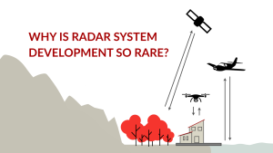
Platform selection: Depending on the coverage needed, SAR systems can be mounted on various platforms, such as drones or aircraft. The platform determines key operational constraints like size, weight, and power supply.
Resolution vs. area: High-resolution SAR systems provide detailed imagery but may cover smaller areas. A balance between resolution and coverage is essential based on the client’s needs.
SAR systems tend to be more complex and expensive to develop, so timeline and budget are key factors during the design phase.
Read More about Synthetic Aperture Radar
Use Case: Optical Imagery
High-Resolution Visual Data for Detailed Analysis
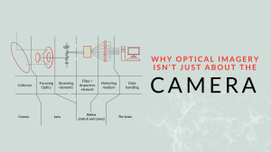
Optical imagery is the go-to technology for detailed, high-resolution, and immediately intuitive data. This is often used in urban planning, engineering, and precision agriculture industries. The ability to capture real-time, high-quality images makes Optical Imagery indispensable for tasks that require accuracy and visual clarity.
Key considerations when designing an Optical Imagery system include:
Resolution needs: Higher-resolution imagery offers more detail but requires more storage and processing power. The necessary level of detail will guide decisions on the type of camera and lens systems to use.
Environmental factors: Unlike SAR, Optical Imagery systems can be affected by weather and lighting conditions. Cloud cover and low-light environments may require additional technologies, such as infrared or low-light imaging.
Platform and sensor integration: Similar to SAR, Optical Imagery systems can be deployed on various platforms. Ensuring the sensor system is well-integrated with the platform is essential for consistent data collection.
In cases where high-resolution imagery is a priority, the focus will be on optimizing camera and optical components for sharpness and clarity.
Read More about Optical Imagery
Use Case: Near Infrared (Near IR)
Monitoring Vegetation and Detecting Subtle Changes
Near Infrared technology is widely used to detect variations in vegetation, water content, and temperature, making it essential for agricultural monitoring and environmental studies. Near IR sensors capture data beyond the visible spectrum, providing unique insights into plant health, moisture levels, and other conditions visible to the naked eye.
Considerations for designing a Near IR system include:
Wavelength requirements: The specific wavelength range needed will depend on the application. For instance, agricultural monitoring may require specific Near IR wavelengths to assess plant health.
Platform and data processing: Near IR systems are often deployed on airborne platforms like drones or managed aircraft to cover large agricultural areas. Data processing and storage must be robust enough to handle the specialized data that Near IR systems capture.
Integration with analytics: Near IR data is often combined with other data sources to create a more comprehensive picture. This ensures the system integrates smoothly with data analysis tools, which is critical to delivering actionable insights.
Read More about Near Infrared
Platform and Operational Considerations
Regardless of the technology, designing a custom system requires careful thought about the platform. Whether mounted on an aircraft, ground vehicle, or stationary installation, each platform has unique requirements that will affect the system’s design. Factors such as weight limits, power availability, and environmental durability must be accounted for initially.
Other key operational considerations include:
Data collection frequency: How often data needs to be collected will affect sensor choices and power management.
Budget and timeline: Fully custom systems offer more control but take longer and cost more to develop. Using existing components, a hybrid approach can offer faster and more cost-effective solutions.
Designing a custom remote sensing system is a complex process that requires balancing client needs, technological capabilities, and practical constraints. By focusing on the specific use cases, it’s possible to create systems that deliver accurate, actionable data while fitting into a client’s operational framework.
Learn more about the custom systems we design at GNO-SYS here.