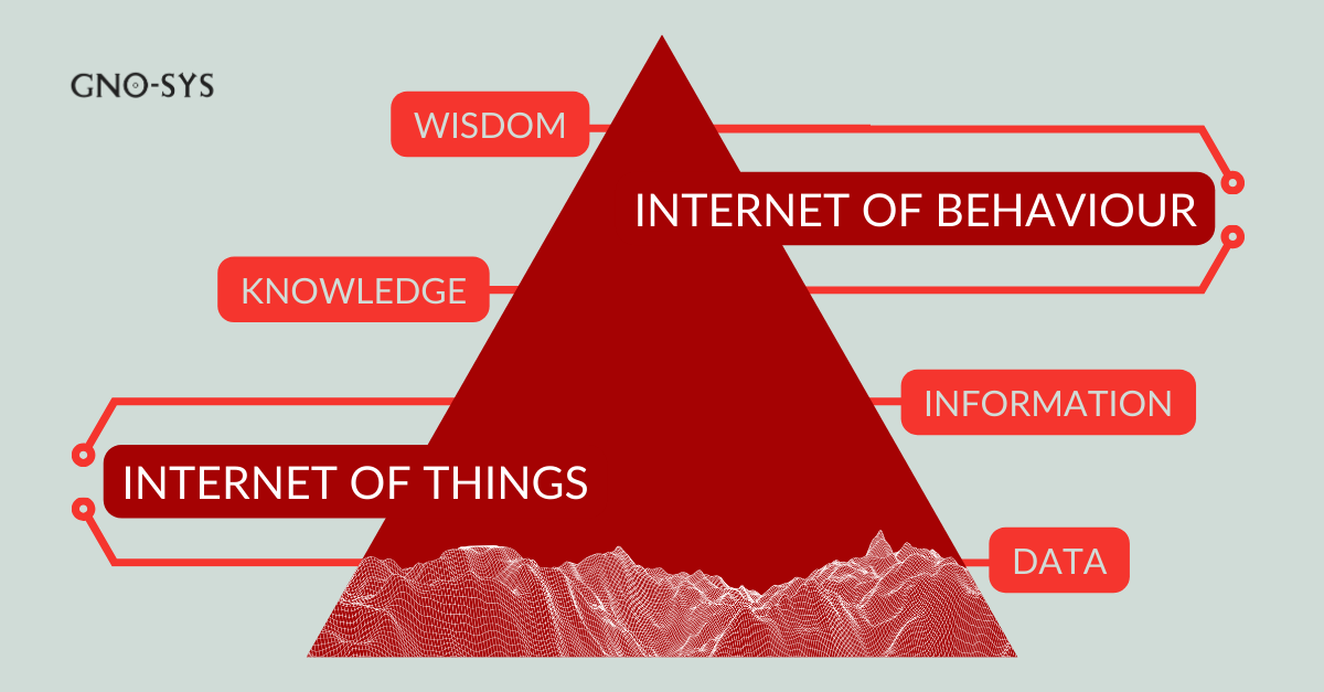
Where AI Fits in Geospatial Workflows and Where it Doesn’t (Part 1 of 4)
Shahab Bahreini Jangoo, Software Developer, GNO-SYS

Shahab Bahreini Jangoo, Software Developer, GNO-SYS

High‑resolution airborne imagery is only as valuable as the trust you can place in the data behind it. At GNO‑SYS, that trust does not happen by chance. It is engineered through careful lens calibration, rigorous testing, and deep technical expertise. This story isn’t about a new lens. It is about

Across Canada, wildfire seasons are becoming more unpredictable, more intense, and more difficult to model using traditional methods. To support decision makers who depend on accurate, forward‑looking intelligence, Traverse Analytics and GNO‑SYS have developed a scalable, production‑grade wildfire risk prediction model capable of analyzing more than 1.58 million km² of

A GNO SYS and ICEYE Story When ICEYE needed a reliable way to verify the accuracy of their satellite radar measurements, they partnered with GNO SYS to build the ground reference points that would make it possible. Our team designed and installed custom corner reflectors that give ICEYE a clear

Design: The Blueprint for High-Altitude Imaging Every great camera starts on paper. At GNO-SYS, we believe that designing advanced imaging systems begins with first principles: understanding the end goal and building every component to serve that purpose. In this case with IO Aerospace, the goal was clear: wide-area, high-resolution coverage

In mapping, data quality comes down to precision, and at GNO-SYS, our laser systems are engineered to deliver high accuracy in some of the world’s most challenging environments. At the heart of that capability is Katrina, our Laser Test and Operations Specialist. We sat down with Katrina to talk about

When it comes to complex sensing missions, the aircraft is more than just a platform, it’s a flying lab, communication hub, and precision instrument. At GNO-SYS, we specialize in designing and operating custom-configured aircraft that bring together multiple sensors, data systems, and communication tools into a cohesive, high-performance package. Here’s

As wildfires become more frequent and severe, the need for reliable, real-time information is more critical than ever. One of the most valuable tools in the wildfire management toolkit is the thermal sensor. These devices can detect and map heat, even when smoke, darkness, or terrain make visibility difficult.

Radar has earned a reputation in remote sensing for being among the most powerful and complex technologies to work with. While satellite radar systems have become more common, airborne radar systems designed specifically for mapping purposes remain rare. And for good reason: building and operating a radar system from scratch

When we set out to develop a high-performance optical imaging system, we start where many do – testing commercial off-the-shelf cameras. The idea was simple: find a camera with the right specifications and integrate it into an aerial platform. But as we quickly learned, optical imaging for aerial applications is

At GNO-SYS, we specialize in engineering LiDAR systems that deliver precise distance measurement and topographic mapping. Currently, our team is engaged in an exciting project to develop a custom LiDAR system tailored for a specialized application.

When it comes to high-resolution imaging for both airborne and space applications, Synthetic Aperture Radar (SAR) systems provide unique advantages. SAR technology, increasingly popular over the past decade in satellite imaging, enables precise, high-resolution data collection that traditional optical systems can’t match, especially in challenging conditions. For satellites, particularly those

Many factors must be closely assessed when designing custom remote sensing systems. Whether using SAR, Optical Imagery, or Near Infrared, each system must align with the specific needs of the client and the data needed. From resolution to data collection to platform integration to budget, the timeline for all factors

Have you ever wondered how much your location data can tell about your daily habits? With the increasing adoption of Internet of Things (IoT) devices, this data is becoming a goldmine for understanding human behavior. In fact, a report predicts that by 2030, 75% of all devices will be IoT

Discover the importance of a data automation strategy and learn about the GNOde Guided Approach. Optimize your data processes with customized workflows, API integration, and scalable solutions for enhanced efficiency and productivity.

Discover how the geospatial industry is battling wildfires through predictive modeling, real-time monitoring, and emergency planning. Learn about companies making a difference in wildfire management and post-fire recovery. Explore the vital role of spatial technology in safeguarding communities and preserving our environment.

The Crucial Role of Geospatial Technology in Oil & Gas In the Canadian oil and gas industry, geospatial technology is a vital ally, seamlessly integrating data-driven insights to enhance exploration, production, and decision-making processes. This blog will dig into how the geospatial industry serves the specific needs of the oil

HaySTAC: Streamlining Geospatial Data Management with Compliance and Security Data has become the driving force behind many critical decisions today. Geospatial data, in particular, plays a crucial role in various industries, including transportation, agriculture, and urban planning. However, managing geospatial data can be a daunting task, especially when it comes

Optimizing Lidar Processing with Customized Workflows Why does lidar data processing matter? Lidar has become a cornerstone technology for many applications, from topographic mapping and urban planning to digital terrain models and environmental monitoring. As lidar datasets grow in complexity and volume, the need for efficient and customized processing workflows

GNO-SYS – Who We Are and Who We Serve Unlocking Solutions, Simplifying Complexity In the vast and intricate realm of geospatial technology, GNO-SYS stands for practical expertise, offering innovative solutions that are reliable and scalable. Our mission is simple yet profound – to mix curiosity with innovation and intentionally solve

Founder Insights: Jonathan’s Top 5 Trends for Geospatial Let’s discuss where I see the significant gains in #geospatial technology will come from over the next 3-5 years. I’ve been excited about the upcoming innovations that will revolutionize our industry. Here are my top 5: 1. Climate Change: A Call to

GNOde: A Comprehensive Overview In the ever-evolving landscape of geospatial technology, harnessing the potential of data is paramount for professionals ranging from GIS technicians and engineers to scientists. Enter GNOde, a powerful cloud-based platform designed for managing and analyzing geospatial data. With its innovative features, GNOde has the potential to revolutionize

Automated Data Processing and Change Detection Recently we’ve been working on a few projects that involve change detection in satellite imagery. Change detection has been a mainstay of the remote sensing industry since its inception but today’s change detection has evolved a long way from what it used to be.

GNO-SYS Technology; Year 2023 in Review As 2023 comes to a close, we’re excited to reflect on a year filled with great projects and achievements. Here’s a glimpse into some of the remarkable initiatives that defined our year: 1. GNOde: Geospatial Data Management and Analysis We proudly launched GNOde, our

Data Processing vs. Data Management – Finding value in your data In today’s data driven world, organizations and individuals rely heavily on the effective handling and use of data. When done correctly we can assess and gain valuable insights from data which allows for informed decision-making, technological progress and further

GNO-SYS guide to a seamless sensor integration Recently we had the privilege of supporting IO Aerospace in the integration of sensor technology on their newly transformed IO Special Missions Platform. With our expertise in sensors, we were brought in to support the installation and ensure a smooth integration process. However,

NORTH51 Highlights & Recap This month we had the privilege of gathering with thought leaders and innovators from all around the world at the NORTH51 Conference in Banff, Alberta. It was an honor to partner with Sparkgeo to bring back this event for its fifth year. During the conference we

GNO-SYS will be working with 4th Resource to aid in development of geothermal resources around the world.

Understanding STAC Spatio-Temporal Asset Catalog (STAC) specification provides a common structure for describing and cataloging spatiotemporal data products in a uniform, extensible manner. The STAC specification is composed of four semi-independent components which can be used alone but work best in concert with each other. The four components are as

Creating geospatial infrastructure into a
reliable, repeatable, and robust system
that allows anyone to collaborative and create products from data collected in space

LiDAR Data is expensive to collect, and when you’re operating multiple sensors you need to manage all that data properly. Learn about the value of a consistent data structure and how it unlocks automation

LiDAR Surveys are becoming more and more common as the technology evolves.
Regardless of the survey specifics, GNO-SYS has found that clients succeed best when they follow these steps.